

Task 1 · map · 18 samples

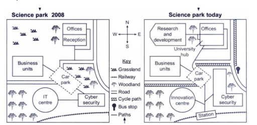
The maps below show a science park in 2008 and the same park today. Summarise the information by selecting and reporting the main features, and make comparisons where relevant.

Data or diagram for the writing questionPractise this task →

Plan your answer

Try your own response before reading the samples.

Ideas to explore

  • Separate features that remain from those that have been added, relocated or replaced; the business units and car park remain, while the IT centre gives way to an innovation centre.
  • Describe the shift in land use: open grassland in the northwest is now substantially developed, while trees remain in the southwest.
  • Treat transport access as a key change, noting the cycle path, station and bus stop, while also mentioning the railway that continues to border the site.

Suggested structure

  1. Introduce the maps and identify the time comparison.
  2. Give an overview of the most important changes: redevelopment and improved access.
  3. Describe the 2008 arrangement by area, covering open land and existing facilities.
  4. Compare the current layout, highlighting retained and replaced buildings.
  5. Finish with access changes and any transport feature that remains.
Useful vocabulary & examples
give way to
to be replaced by something new

The IT centre has given way to an innovation centre.

remain in broadly similar positions
to stay in approximately the same locations

The business units remain in broadly similar positions.

be concentrated in
to be located mainly within a particular area

Woodland was concentrated in the southwest.

border the site
to run along the edge of an area

The railway continues to border the site to the east.

Sample answers

AI-completed learning example

215 words · Illustrative target band

The maps compare the layout of a science park in 2008 and its current configuration. Overall, the park has undergone significant changes by modernising its facilities and improving its accessibility. In 2008, woodland and grassland occupied the northwest and southwest sides of the park and a small area adjacent to a car park in the centre. The park's built facilities were concentrated mainly in the north and east, wh…

Read full answer & analysis →

AI-completed learning example

251 words · Illustrative target band

The map details alterations to the science park since 2008. Looking from an overall perspective, it is readily apparent that this park has become more accessible, with cycle paths and bus stops; more commercial, with a station; and more educational, with a university hub. These changes have been made at the expense of grasslands and some of the earlier open space. The station improves transport access; it does not by…

Read full answer & analysis →

AI-completed learning example

195 words · Illustrative target band

The map illustrates the buildings and roads of the science park at the present day and how it looked in 2008. Overall, it is noticeable that many new cycle paths were built, and all of the grasslands were demolished. Looking at the information in more detail, there were three new cycle paths constructed; two of them are located in the eastern part of the park, while the other crosses the central area. In 2008, the no…

Read full answer & analysis →