User-written IELTS example
Writing Academic Task 1 Band 6.0 Example
Original task prompt, user essay, band score, and related examples in the same report workspace.
Illustrative target band for this original model answer.
Plan your answer
Try your own response before reading the samples.
Ideas to explore
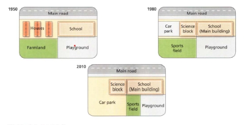
- Trace how the western side changed from houses and farmland to a car park and sports field, then to an expanded car park and smaller sports field.
- Note that the science block appears by 1980, while the main school building stays in the northeastern area.
- Identify features that remain broadly stable across the maps, including the main road along the northern boundary and the playground in the southeast.
Suggested structure
- Introduce the dates and identify the maps as changes to the school site.
- Give an overview of the main redevelopment and the features that remain.
- Describe the 1950 layout using clear directional references.
- Compare the main additions and replacements in 1980 and 2010.
- End with the most notable change, such as the car park’s expansion and the sports field’s reduction.
Useful vocabulary & examples
- occupy the western side
- be located across the western part of a site
By 2010, the car park occupied most of the western side.
- be replaced by
- be removed and have something else put in its place
The houses and farmland were replaced by facilities for parking and sport.
- expand southwards
- increase in size toward the south
The car park expanded southwards between 1980 and 2010.
- remain in the northeastern area
- stay broadly in the northeast part of a location
The main school building remained in the northeastern area of the site.
Task Prompt
User Essay Analysis
Review the public answer with report-style highlights.
The diagram represents how West Park Secondary School changed over the years since its construction in 1950. Overall, the school and playground have remained in their original state since their opening in 1950. However, on today’s map, we see that a new additional building called Science Block has been built, and the size of the car park and sports areas have also changed. In 1950, houses occupied the north-western section, the school stood in the north-east, farmland covered the south-west, and the playground lay in the south-east. By 1980, the houses and farmland had disappeared. A car park and sports field had taken over the western side, while the Science Block was added between the car park and the main school building. In 2010, the car park occupied most of the western area, and the Science Block and main building were positioned along the northern side. The sports field had become a narrow central strip in the south, with the playground remaining to its right. Thus, although the main school building and playground retained broadly similar eastern locations, the grounds were substantially reorganised, with residential and farm land replaced by parking and sports facilities.
Targeted Improvement Tips
Related examples for this topic
Compare different bands on the same IELTS prompt.
The diagrams depict the evolution of West Park Secondary School from its inception in 1950 to the alterations observed in 2010. Overall, the maps illustrate a significant transf...
Band 8.0The three different maps illustrate that significant changes have occurred at West Park Secondary School between 1950 and 2010. Additionally, there is an interim map that outlin...
Band 7.0The diagrams give information about the construction of buildings in West Park Secondary school from the period of 1950 to 2010. Firstly, the school (main building) throughout t...
Band 6.0The maps illustrate how West Park Secondary School has transformed over time, 1950, 1980, and 2010. Overall, it can be seen that the school had undergone some significant change...
Band 5.0The photos illustrate a reconstruction of the West park Secondary School from 1950 to 2010. Overall, location and the size of the main road remained the same and the placement o...
Band 4.0The diagrams illustrate the reconstruction of West Park Secondary School over the 30 years since 1950. There was a unit that had been removed, while the other had been built and...
